|
|
|||||||||||||||||
| Point ID: 2945 | Downloads | Plots | Site Data | Code: 05NG016 |
|
|
|||||||||||||||||
| Download | |
|---|---|
| Site Descriptor Information | Site Time Series Data |
| Link to all available data | |
| View: | Time Series | All |
| Units: | mm |
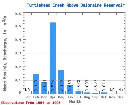
| Statistic | Jan | Feb | Mar | Apr | May | Jun | Jul | Aug | Sep | Oct | Nov | Dec | Annual |
|---|---|---|---|---|---|---|---|---|---|---|---|---|---|
| Mean | 0.14 | 0.08 | 0.53 | 0.17 | 0.06 | 0.02 | 0.01 | 0.01 | 0.01 | ||||
| Standard Deviation | 0.15 | 0.66 | 0.22 | 0.13 | 0.04 | 0.04 | 0.02 | 0.03 | |||||
| Min | 0.14 | 0.00 | 0.00 | 0.00 | 0.00 | 0.00 | 0.00 | 0.00 | 0.00 | ||||
| Max | 0.14 | 0.78 | 2.38 | 0.79 | 0.67 | 0.23 | 0.20 | 0.09 | 0.16 | ||||
| Coefficient of Variation | 1.84 | 1.25 | 1.26 | 2.05 | 2.25 | 4.02 | 3.04 | 3.09 |
 Return to R-Arctic Net Home Page