|
|
|||||||||||||||||
| Point ID: 2945 | Downloads | Plots | Site Data | Code: 05NG016 |
|
|
|||||||||||||||||
| Download | |
|---|---|
| Site Descriptor Information | Site Time Series Data |
| Link to all available data | |
| View: | Time Series | All |
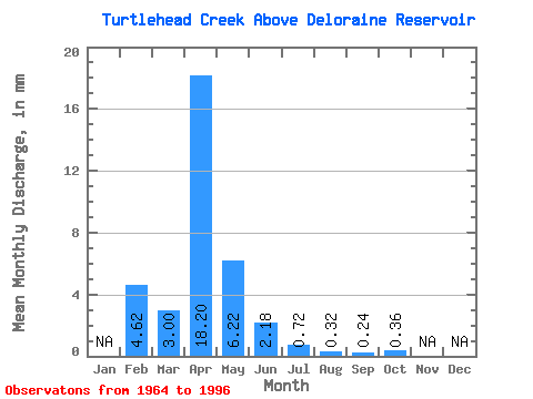
| Units: | m3/s |
| Statistic | Jan | Feb | Mar | Apr | May | Jun | Jul | Aug | Sep | Oct | Nov | Dec | Annual |
|---|---|---|---|---|---|---|---|---|---|---|---|---|---|
| Mean | 4.66 | 3.00 | 18.22 | 6.23 | 2.17 | 0.70 | 0.31 | 0.23 | 0.36 | ||||
| Standard Deviation | 5.53 | 22.84 | 7.85 | 4.45 | 1.57 | 1.25 | 0.69 | 1.11 | |||||
| Min | 4.66 | 0.00 | 0.04 | 0.04 | 0.00 | 0.00 | 0.00 | 0.00 | 0.00 | ||||
| Max | 4.66 | 27.85 | 82.36 | 28.32 | 23.19 | 8.08 | 7.12 | 3.08 | 5.79 | ||||
| Coefficient of Variation | 1.84 | 1.25 | 1.26 | 2.05 | 2.25 | 4.02 | 3.04 | 3.09 |
 Return to R-Arctic Net Home Page