|
|
|||||||||||||||||
| Point ID: 2942 | Downloads | Plots | Site Data | Code: 05NG010 |
|
|
|||||||||||||||||
| Download | |
|---|---|
| Site Descriptor Information | Site Time Series Data |
| Link to all available data | |
| View: | Time Series | All |
| Units: | mm |
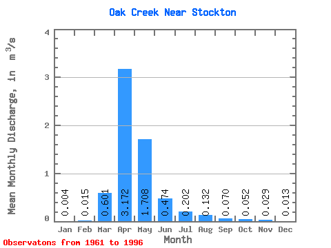
| Statistic | Jan | Feb | Mar | Apr | May | Jun | Jul | Aug | Sep | Oct | Nov | Dec | Annual |
|---|---|---|---|---|---|---|---|---|---|---|---|---|---|
| Mean | 0.00 | 0.01 | 0.60 | 3.17 | 1.71 | 0.47 | 0.20 | 0.13 | 0.07 | 0.05 | 0.03 | 0.01 | 0.56 |
| Standard Deviation | 0.01 | 0.05 | 0.98 | 4.36 | 2.25 | 0.59 | 0.22 | 0.17 | 0.11 | 0.09 | 0.08 | 0.04 | 0.66 |
| Min | 0.00 | 0.00 | 0.00 | 0.00 | 0.00 | 0.00 | 0.00 | 0.00 | 0.00 | 0.00 | 0.00 | 0.00 | 0.00 |
| Max | 0.02 | 0.26 | 4.02 | 18.80 | 8.72 | 2.33 | 0.79 | 0.65 | 0.37 | 0.31 | 0.41 | 0.17 | 2.23 |
| Coefficient of Variation | 1.22 | 3.63 | 1.64 | 1.37 | 1.32 | 1.24 | 1.10 | 1.26 | 1.56 | 1.71 | 2.87 | 2.62 | 1.19 |
 Return to R-Arctic Net Home Page