|
|
|||||||||||||||||
| Point ID: 2942 | Downloads | Plots | Site Data | Code: 05NG010 |
|
|
|||||||||||||||||
| Download | |
|---|---|
| Site Descriptor Information | Site Time Series Data |
| Link to all available data | |
| View: | Time Series | All |
| Units: | m3/s |
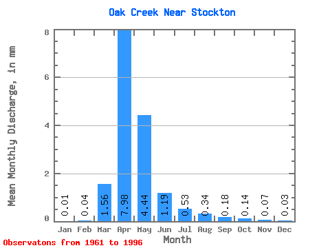
| Statistic | Jan | Feb | Mar | Apr | May | Jun | Jul | Aug | Sep | Oct | Nov | Dec | Annual |
|---|---|---|---|---|---|---|---|---|---|---|---|---|---|
| Mean | 0.01 | 0.04 | 1.56 | 7.98 | 4.44 | 1.19 | 0.53 | 0.34 | 0.18 | 0.13 | 0.07 | 0.04 | 17.01 |
| Standard Deviation | 0.01 | 0.13 | 2.56 | 10.97 | 5.84 | 1.48 | 0.58 | 0.43 | 0.28 | 0.23 | 0.21 | 0.09 | 20.31 |
| Min | 0.00 | 0.00 | 0.00 | 0.01 | 0.00 | 0.00 | 0.00 | 0.00 | 0.00 | 0.00 | 0.00 | 0.00 | 0.09 |
| Max | 0.04 | 0.61 | 10.45 | 47.31 | 22.67 | 5.86 | 2.04 | 1.68 | 0.93 | 0.81 | 1.04 | 0.45 | 68.21 |
| Coefficient of Variation | 1.22 | 3.63 | 1.64 | 1.37 | 1.32 | 1.24 | 1.10 | 1.26 | 1.56 | 1.71 | 2.87 | 2.62 | 1.19 |
 Return to R-Arctic Net Home Page