|
|
|||||||||||||||||
| Point ID: 2934 | Downloads | Plots | Site Data | Other Close Sites | Code: 05NF012 |
|
|
|||||||||||||||||
| Download | |
|---|---|
| Site Descriptor Information | Site Time Series Data |
| Link to all available data | |
| View: | Time Series | All |
| Units: | mm |
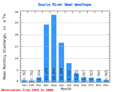
| Statistic | Jan | Feb | Mar | Apr | May | Jun | Jul | Aug | Sep | Oct | Nov | Dec | Annual |
|---|---|---|---|---|---|---|---|---|---|---|---|---|---|
| Mean | 0.76 | 0.75 | 2.00 | 24.20 | 28.34 | 16.59 | 8.01 | 3.67 | 2.07 | 1.92 | 1.56 | 0.96 | 7.63 |
| Standard Deviation | 1.12 | 1.13 | 3.83 | 39.25 | 41.90 | 28.39 | 11.91 | 5.14 | 2.95 | 2.72 | 2.35 | 1.38 | 9.86 |
| Min | 0.00 | 0.00 | 0.00 | 0.00 | 0.00 | 0.00 | 0.00 | 0.00 | 0.00 | 0.00 | 0.00 | 0.00 | 0.00 |
| Max | 5.41 | 5.38 | 22.10 | 251.00 | 169.00 | 139.00 | 48.90 | 28.70 | 18.60 | 13.40 | 11.00 | 5.68 | 46.10 |
| Coefficient of Variation | 1.48 | 1.50 | 1.91 | 1.62 | 1.48 | 1.71 | 1.49 | 1.40 | 1.43 | 1.41 | 1.50 | 1.43 | 1.29 |
| Other Close Sites | ||||||
|---|---|---|---|---|---|---|
| PointID | Latitude | Longitude | Drainage Area | Source | Name | |
| 2927 | "SOURIS RIVER AT MELITA" | 49.26 | 844036 | Hydat | ||
| 2932 | "SOURIS RIVER NEAR MELITA" | 49.17 | 850390 | Hydat | ||
| 2937 | "SOURIS RIVER NEAR COULTER" | 49.09 | 845882 | Hydat | ||
| 2951 | "SOURIS RIVER NEAR LAUDER" | 49.40 | 825346 | Hydat | ||
 Return to R-Arctic Net Home Page