|
|
|||||||||||||||||
| Point ID: 2932 | Downloads | Plots | Site Data | Other Close Sites | Code: 05NF009 |
|
|
|||||||||||||||||
| Download | |
|---|---|
| Site Descriptor Information | Site Time Series Data |
| Link to all available data | |
| View: | Time Series | All |
| Units: | mm |
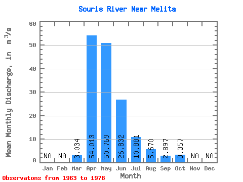
| Statistic | Jan | Feb | Mar | Apr | May | Jun | Jul | Aug | Sep | Oct | Nov | Dec | Annual |
|---|---|---|---|---|---|---|---|---|---|---|---|---|---|
| Mean | 3.03 | 54.01 | 50.77 | 26.83 | 10.88 | 5.67 | 2.90 | 3.36 | |||||
| Standard Deviation | 5.20 | 96.98 | 65.95 | 34.48 | 11.87 | 5.47 | 2.75 | 5.21 | |||||
| Min | 0.01 | 0.05 | 0.03 | 0.42 | 0.42 | 0.47 | 0.23 | 0.41 | |||||
| Max | 17.00 | 358.00 | 212.00 | 100.00 | 36.90 | 16.70 | 8.79 | 21.00 | |||||
| Coefficient of Variation | 1.71 | 1.80 | 1.30 | 1.28 | 1.09 | 0.96 | 0.95 | 1.55 |
| Other Close Sites | ||||||
|---|---|---|---|---|---|---|
| PointID | Latitude | Longitude | Drainage Area | Source | Name | |
| 2927 | "SOURIS RIVER AT MELITA" | 49.26 | 844036 | Hydat | ||
| 2934 | "SOURIS RIVER NEAR WESTHOPE" | 48.99 | 847860 | Hydat | ||
| 2937 | "SOURIS RIVER NEAR COULTER" | 49.09 | 845882 | Hydat | ||
| 2951 | "SOURIS RIVER NEAR LAUDER" | 49.40 | 825346 | Hydat | ||
 Return to R-Arctic Net Home Page