|
|
|||||||||||||||||
| Point ID: 2919 | Downloads | Plots | Site Data | Code: 05MJ003 |
|
|
|||||||||||||||||
| Download | |
|---|---|
| Site Descriptor Information | Site Time Series Data |
| Link to all available data | |
| View: | Time Series | All |
| Units: | mm |
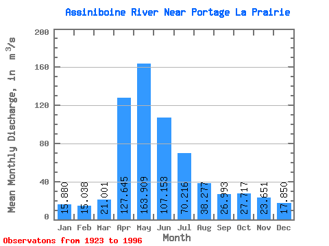
| Statistic | Jan | Feb | Mar | Apr | May | Jun | Jul | Aug | Sep | Oct | Nov | Dec | Annual |
|---|---|---|---|---|---|---|---|---|---|---|---|---|---|
| Mean | 15.88 | 15.04 | 21.00 | 127.64 | 163.91 | 107.15 | 70.22 | 38.28 | 26.99 | 27.72 | 23.65 | 17.85 | 52.28 |
| Standard Deviation | 9.61 | 8.42 | 12.47 | 86.29 | 133.36 | 95.17 | 66.84 | 32.49 | 17.47 | 19.29 | 14.84 | 11.50 | 35.00 |
| Min | 1.67 | 0.90 | 4.25 | 22.10 | 16.30 | 11.30 | 5.65 | 3.41 | 4.82 | 7.73 | 7.96 | 3.19 | 10.94 |
| Max | 46.40 | 39.00 | 51.30 | 342.00 | 487.00 | 387.00 | 321.00 | 131.00 | 74.00 | 101.00 | 72.10 | 56.80 | 138.78 |
| Coefficient of Variation | 0.60 | 0.56 | 0.59 | 0.68 | 0.81 | 0.89 | 0.95 | 0.85 | 0.65 | 0.70 | 0.63 | 0.64 | 0.67 |
 Return to R-Arctic Net Home Page