|
|
|||||||||||||||||
| Point ID: 2919 | Downloads | Plots | Site Data | Code: 05MJ003 |
|
|
|||||||||||||||||
| Download | |
|---|---|
| Site Descriptor Information | Site Time Series Data |
| Link to all available data | |
| View: | Time Series | All |
| Units: | m3/s |
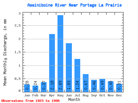
| Statistic | Jan | Feb | Mar | Apr | May | Jun | Jul | Aug | Sep | Oct | Nov | Dec | Annual |
|---|---|---|---|---|---|---|---|---|---|---|---|---|---|
| Mean | 0.28 | 0.24 | 0.37 | 2.18 | 2.89 | 1.83 | 1.24 | 0.67 | 0.46 | 0.49 | 0.40 | 0.31 | 10.86 |
| Standard Deviation | 0.17 | 0.14 | 0.22 | 1.47 | 2.35 | 1.62 | 1.18 | 0.57 | 0.30 | 0.34 | 0.25 | 0.20 | 7.27 |
| Min | 0.03 | 0.01 | 0.07 | 0.38 | 0.29 | 0.19 | 0.10 | 0.06 | 0.08 | 0.14 | 0.14 | 0.06 | 2.27 |
| Max | 0.82 | 0.63 | 0.90 | 5.83 | 8.58 | 6.60 | 5.66 | 2.31 | 1.26 | 1.78 | 1.23 | 1.00 | 28.81 |
| Coefficient of Variation | 0.60 | 0.56 | 0.59 | 0.68 | 0.81 | 0.89 | 0.95 | 0.85 | 0.65 | 0.70 | 0.63 | 0.64 | 0.67 |
 Return to R-Arctic Net Home Page