|
|
|||||||||||||||||
| Point ID: 2909 | Downloads | Plots | Site Data | Code: 05MH002 |
|
|
|||||||||||||||||
| Download | |
|---|---|
| Site Descriptor Information | Site Time Series Data |
| Link to all available data | |
| View: | Time Series | All |
| Units: | mm |
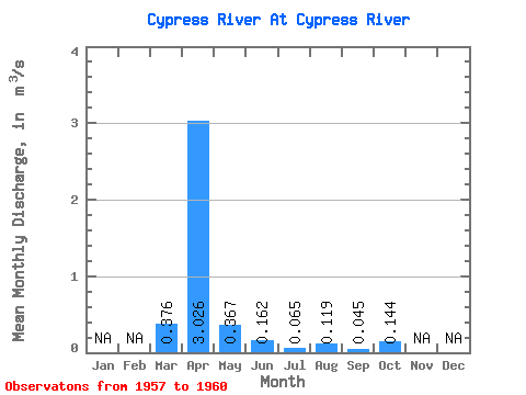
| Statistic | Jan | Feb | Mar | Apr | May | Jun | Jul | Aug | Sep | Oct | Nov | Dec | Annual |
|---|---|---|---|---|---|---|---|---|---|---|---|---|---|
| Mean | 0.38 | 3.03 | 0.37 | 0.16 | 0.07 | 0.12 | 0.04 | 0.14 | |||||
| Standard Deviation | 0.26 | 2.88 | 0.20 | 0.13 | 0.02 | 0.20 | 0.06 | 0.25 | |||||
| Min | 0.07 | 0.80 | 0.19 | 0.04 | 0.04 | 0.00 | 0.00 | 0.00 | |||||
| Max | 0.54 | 6.98 | 0.56 | 0.34 | 0.08 | 0.43 | 0.13 | 0.52 | |||||
| Coefficient of Variation | 0.70 | 0.95 | 0.54 | 0.79 | 0.31 | 1.72 | 1.31 | 1.75 |
 Return to R-Arctic Net Home Page