|
|
|||||||||||||||||
| Point ID: 2909 | Downloads | Plots | Site Data | Code: 05MH002 |
|
|
|||||||||||||||||
| Download | |
|---|---|
| Site Descriptor Information | Site Time Series Data |
| Link to all available data | |
| View: | Time Series | All |
| Units: | m3/s |
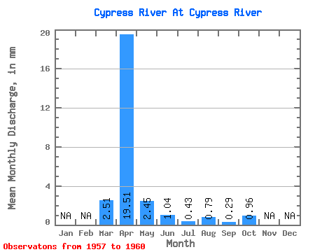
| Statistic | Jan | Feb | Mar | Apr | May | Jun | Jul | Aug | Sep | Oct | Nov | Dec | Annual |
|---|---|---|---|---|---|---|---|---|---|---|---|---|---|
| Mean | 2.50 | 19.51 | 2.45 | 1.04 | 0.43 | 0.79 | 0.29 | 0.96 | |||||
| Standard Deviation | 1.75 | 18.56 | 1.31 | 0.82 | 0.13 | 1.36 | 0.38 | 1.69 | |||||
| Min | 0.49 | 5.17 | 1.25 | 0.24 | 0.24 | 0.00 | 0.00 | 0.00 | |||||
| Max | 3.60 | 45.01 | 3.76 | 2.19 | 0.53 | 2.84 | 0.84 | 3.49 | |||||
| Coefficient of Variation | 0.70 | 0.95 | 0.54 | 0.79 | 0.31 | 1.72 | 1.31 | 1.75 |
 Return to R-Arctic Net Home Page