|
|
|||||||||||||||||
| Point ID: 2893 | Downloads | Plots | Site Data | Code: 05MF009 |
|
|
|||||||||||||||||
| Download | |
|---|---|
| Site Descriptor Information | Site Time Series Data |
| Link to all available data | |
| View: | Time Series | All |
| Units: | mm |
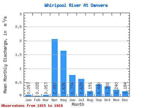
| Statistic | Jan | Feb | Mar | Apr | May | Jun | Jul | Aug | Sep | Oct | Nov | Dec | Annual |
|---|---|---|---|---|---|---|---|---|---|---|---|---|---|
| Mean | 0.06 | 0.03 | 0.06 | 2.06 | 1.64 | 0.77 | 0.63 | 0.19 | 0.44 | 0.35 | 0.24 | 0.18 | |
| Standard Deviation | 1.24 | 0.87 | 0.91 | 0.73 | 0.12 | 0.25 | 0.26 | 0.22 | 0.14 | ||||
| Min | 0.06 | 0.03 | 0.06 | 0.73 | 0.75 | 0.26 | 0.18 | 0.06 | 0.17 | 0.10 | 0.11 | 0.09 | |
| Max | 0.06 | 0.03 | 0.06 | 3.53 | 2.57 | 2.39 | 1.93 | 0.38 | 0.81 | 0.66 | 0.57 | 0.28 | |
| Coefficient of Variation | 0.60 | 0.53 | 1.18 | 1.17 | 0.62 | 0.57 | 0.74 | 0.93 | 0.76 |
 Return to R-Arctic Net Home Page