|
|
|||||||||||||||||
| Point ID: 2893 | Downloads | Plots | Site Data | Code: 05MF009 |
|
|
|||||||||||||||||
| Download | |
|---|---|
| Site Descriptor Information | Site Time Series Data |
| Link to all available data | |
| View: | Time Series | All |
| Units: | m3/s |
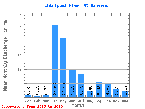
| Statistic | Jan | Feb | Mar | Apr | May | Jun | Jul | Aug | Sep | Oct | Nov | Dec | Annual |
|---|---|---|---|---|---|---|---|---|---|---|---|---|---|
| Mean | 0.73 | 0.33 | 0.73 | 25.64 | 21.05 | 9.64 | 8.09 | 2.45 | 5.48 | 4.57 | 2.98 | 2.37 | |
| Standard Deviation | 15.40 | 11.24 | 11.33 | 9.43 | 1.52 | 3.15 | 3.36 | 2.77 | 1.80 | ||||
| Min | 0.73 | 0.33 | 0.73 | 9.08 | 9.64 | 3.18 | 2.37 | 0.82 | 2.13 | 1.34 | 1.42 | 1.09 | |
| Max | 0.73 | 0.33 | 0.73 | 43.99 | 33.09 | 29.78 | 24.85 | 4.84 | 10.09 | 8.46 | 7.13 | 3.64 | |
| Coefficient of Variation | 0.60 | 0.53 | 1.18 | 1.17 | 0.62 | 0.57 | 0.74 | 0.93 | 0.76 |
 Return to R-Arctic Net Home Page