|
|
|||||||||||||||||
| Point ID: 2892 | Downloads | Plots | Site Data | Code: 05MF008 |
|
|
|||||||||||||||||
| Download | |
|---|---|
| Site Descriptor Information | Site Time Series Data |
| Link to all available data | |
| View: | Time Series | All |
| Units: | mm |
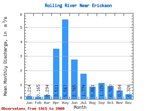
| Statistic | Jan | Feb | Mar | Apr | May | Jun | Jul | Aug | Sep | Oct | Nov | Dec | Annual |
|---|---|---|---|---|---|---|---|---|---|---|---|---|---|
| Mean | 0.21 | 0.17 | 0.29 | 3.51 | 5.57 | 2.77 | 1.77 | 0.86 | 1.12 | 0.92 | 0.58 | 0.33 | 1.46 |
| Standard Deviation | 0.21 | 0.15 | 0.22 | 2.27 | 4.98 | 2.02 | 1.79 | 0.84 | 2.19 | 1.05 | 0.53 | 0.33 | 0.67 |
| Min | 0.00 | 0.00 | 0.01 | 0.64 | 0.13 | 0.12 | 0.01 | 0.00 | 0.01 | 0.04 | 0.10 | 0.03 | 0.53 |
| Max | 1.01 | 0.71 | 1.07 | 10.10 | 25.00 | 8.95 | 9.44 | 3.83 | 12.80 | 5.88 | 2.84 | 1.54 | 3.25 |
| Coefficient of Variation | 0.98 | 0.92 | 0.74 | 0.65 | 0.90 | 0.73 | 1.01 | 0.97 | 1.96 | 1.15 | 0.90 | 1.00 | 0.46 |
 Return to R-Arctic Net Home Page