|
|
|||||||||||||||||
| Point ID: 2892 | Downloads | Plots | Site Data | Code: 05MF008 |
|
|
|||||||||||||||||
| Download | |
|---|---|
| Site Descriptor Information | Site Time Series Data |
| Link to all available data | |
| View: | Time Series | All |
| Units: | m3/s |
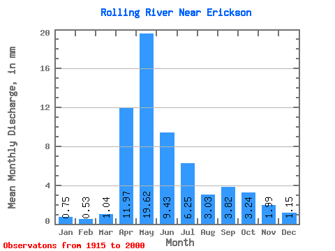
| Statistic | Jan | Feb | Mar | Apr | May | Jun | Jul | Aug | Sep | Oct | Nov | Dec | Annual |
|---|---|---|---|---|---|---|---|---|---|---|---|---|---|
| Mean | 0.75 | 0.53 | 1.03 | 11.97 | 19.62 | 9.43 | 6.25 | 3.03 | 3.82 | 3.24 | 1.99 | 1.15 | 60.41 |
| Standard Deviation | 0.74 | 0.48 | 0.77 | 7.74 | 17.55 | 6.90 | 6.30 | 2.95 | 7.48 | 3.71 | 1.80 | 1.15 | 27.81 |
| Min | 0.00 | 0.00 | 0.04 | 2.19 | 0.47 | 0.42 | 0.03 | 0.00 | 0.02 | 0.14 | 0.33 | 0.10 | 22.00 |
| Max | 3.56 | 2.29 | 3.77 | 34.45 | 88.09 | 30.52 | 33.26 | 13.50 | 43.66 | 20.72 | 9.69 | 5.43 | 134.82 |
| Coefficient of Variation | 0.98 | 0.92 | 0.74 | 0.65 | 0.90 | 0.73 | 1.01 | 0.97 | 1.96 | 1.15 | 0.90 | 1.00 | 0.46 |
 Return to R-Arctic Net Home Page