|
|
|||||||||||||||||
| Point ID: 289 | Downloads | Plots | Site Data | Code: 05BH013 |
|
|
|||||||||||||||||
| Download | |
|---|---|
| Site Descriptor Information | Site Time Series Data |
| Link to all available data | |
| View: | Time Series | All |
| Units: | mm |
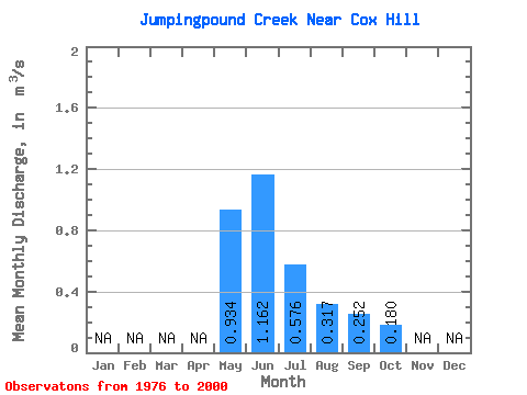
| Statistic | Jan | Feb | Mar | Apr | May | Jun | Jul | Aug | Sep | Oct | Nov | Dec | Annual |
|---|---|---|---|---|---|---|---|---|---|---|---|---|---|
| Mean | 0.93 | 1.16 | 0.58 | 0.32 | 0.25 | 0.18 | |||||||
| Standard Deviation | 0.64 | 0.77 | 0.50 | 0.24 | 0.23 | 0.18 | |||||||
| Min | 0.18 | 0.26 | 0.14 | 0.09 | 0.05 | 0.06 | |||||||
| Max | 2.60 | 3.00 | 2.00 | 1.02 | 1.08 | 0.96 | |||||||
| Coefficient of Variation | 0.69 | 0.66 | 0.86 | 0.76 | 0.92 | 1.00 |
 Return to R-Arctic Net Home Page