|
|
|||||||||||||||||
| Point ID: 289 | Downloads | Plots | Site Data | Code: 05BH013 |
|
|
|||||||||||||||||
| Download | |
|---|---|
| Site Descriptor Information | Site Time Series Data |
| Link to all available data | |
| View: | Time Series | All |
| Units: | m3/s |
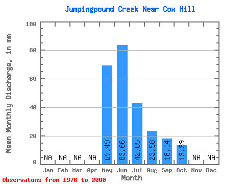
| Statistic | Jan | Feb | Mar | Apr | May | Jun | Jul | Aug | Sep | Oct | Nov | Dec | Annual |
|---|---|---|---|---|---|---|---|---|---|---|---|---|---|
| Mean | 69.50 | 83.69 | 42.85 | 23.61 | 18.17 | 13.40 | |||||||
| Standard Deviation | 47.59 | 55.48 | 36.89 | 17.81 | 16.72 | 13.34 | |||||||
| Min | 13.39 | 18.58 | 10.41 | 6.32 | 3.89 | 4.32 | |||||||
| Max | 193.41 | 216.00 | 148.78 | 75.88 | 77.76 | 71.34 | |||||||
| Coefficient of Variation | 0.69 | 0.66 | 0.86 | 0.76 | 0.92 | 1.00 |
 Return to R-Arctic Net Home Page