|
|
|||||||||||||||||
| Point ID: 2888 | Downloads | Plots | Site Data | Code: 05MF004 |
|
|
|||||||||||||||||
| Download | |
|---|---|
| Site Descriptor Information | Site Time Series Data |
| Link to all available data | |
| View: | Time Series | All |
| Units: | mm |
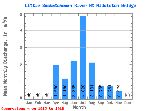
| Statistic | Jan | Feb | Mar | Apr | May | Jun | Jul | Aug | Sep | Oct | Nov | Dec | Annual |
|---|---|---|---|---|---|---|---|---|---|---|---|---|---|
| Mean | 1.99 | 1.19 | 2.23 | 4.83 | 2.13 | 0.73 | 0.78 | 0.47 | |||||
| Standard Deviation | 2.61 | 5.78 | 2.12 | 0.42 | 0.45 | 0.32 | |||||||
| Min | 1.99 | 1.19 | 0.39 | 0.74 | 0.63 | 0.44 | 0.46 | 0.25 | |||||
| Max | 1.99 | 1.19 | 4.08 | 8.91 | 3.63 | 1.03 | 1.10 | 0.70 | |||||
| Coefficient of Variation | 1.17 | 1.20 | 0.99 | 0.57 | 0.58 | 0.67 |
 Return to R-Arctic Net Home Page