|
|
|||||||||||||||||
| Point ID: 2888 | Downloads | Plots | Site Data | Code: 05MF004 |
|
|
|||||||||||||||||
| Download | |
|---|---|
| Site Descriptor Information | Site Time Series Data |
| Link to all available data | |
| View: | Time Series | All |
| Units: | m3/s |
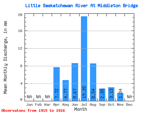
| Statistic | Jan | Feb | Mar | Apr | May | Jun | Jul | Aug | Sep | Oct | Nov | Dec | Annual |
|---|---|---|---|---|---|---|---|---|---|---|---|---|---|
| Mean | 7.72 | 4.77 | 8.67 | 19.35 | 8.54 | 2.85 | 3.13 | 1.84 | |||||
| Standard Deviation | 10.12 | 23.15 | 8.50 | 1.62 | 1.81 | 1.24 | |||||||
| Min | 7.72 | 4.77 | 1.52 | 2.98 | 2.53 | 1.71 | 1.85 | 0.96 | |||||
| Max | 7.72 | 4.77 | 15.83 | 35.72 | 14.55 | 4.00 | 4.41 | 2.72 | |||||
| Coefficient of Variation | 1.17 | 1.20 | 0.99 | 0.57 | 0.58 | 0.67 |
 Return to R-Arctic Net Home Page