|
|
|||||||||||||||||
| Point ID: 2879 | Downloads | Plots | Site Data | Code: 05ME001 |
|
|
|||||||||||||||||
| Download | |
|---|---|
| Site Descriptor Information | Site Time Series Data |
| Link to all available data | |
| View: | Time Series | All |
| Units: | mm |
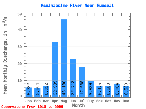
| Statistic | Jan | Feb | Mar | Apr | May | Jun | Jul | Aug | Sep | Oct | Nov | Dec | Annual |
|---|---|---|---|---|---|---|---|---|---|---|---|---|---|
| Mean | 5.78 | 5.50 | 6.92 | 32.94 | 46.19 | 22.71 | 17.99 | 9.53 | 6.47 | 6.66 | 8.00 | 6.52 | 14.63 |
| Standard Deviation | 5.04 | 5.25 | 7.26 | 35.15 | 60.81 | 23.83 | 21.16 | 11.40 | 6.22 | 6.14 | 6.28 | 5.02 | 11.29 |
| Min | 0.62 | 0.59 | 0.92 | 1.19 | 0.65 | 0.69 | 0.60 | 0.35 | 0.23 | 0.23 | 0.37 | 0.55 | 1.90 |
| Max | 23.50 | 23.30 | 30.80 | 185.00 | 323.00 | 129.00 | 96.50 | 72.20 | 29.90 | 41.40 | 42.60 | 21.90 | 57.42 |
| Coefficient of Variation | 0.87 | 0.95 | 1.05 | 1.07 | 1.32 | 1.05 | 1.18 | 1.20 | 0.96 | 0.92 | 0.78 | 0.77 | 0.77 |
 Return to R-Arctic Net Home Page