|
|
|||||||||||||||||
| Point ID: 2879 | Downloads | Plots | Site Data | Code: 05ME001 |
|
|
|||||||||||||||||
| Download | |
|---|---|
| Site Descriptor Information | Site Time Series Data |
| Link to all available data | |
| View: | Time Series | All |
| Units: | m3/s |
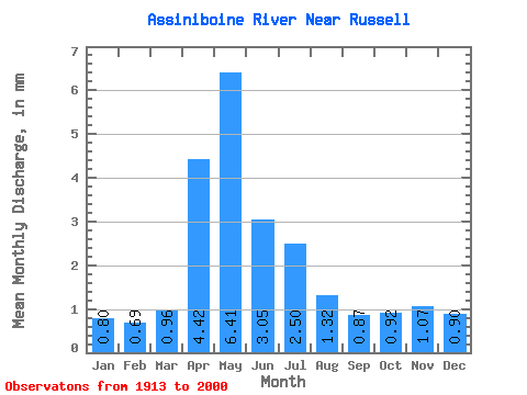
| Statistic | Jan | Feb | Mar | Apr | May | Jun | Jul | Aug | Sep | Oct | Nov | Dec | Annual |
|---|---|---|---|---|---|---|---|---|---|---|---|---|---|
| Mean | 0.80 | 0.70 | 0.96 | 4.42 | 6.41 | 3.05 | 2.50 | 1.32 | 0.87 | 0.92 | 1.07 | 0.91 | 23.93 |
| Standard Deviation | 0.70 | 0.66 | 1.01 | 4.72 | 8.44 | 3.20 | 2.94 | 1.58 | 0.84 | 0.85 | 0.84 | 0.70 | 18.46 |
| Min | 0.09 | 0.07 | 0.13 | 0.16 | 0.09 | 0.09 | 0.08 | 0.05 | 0.03 | 0.03 | 0.05 | 0.08 | 3.11 |
| Max | 3.26 | 2.95 | 4.27 | 24.85 | 44.82 | 17.32 | 13.39 | 10.02 | 4.02 | 5.75 | 5.72 | 3.04 | 93.89 |
| Coefficient of Variation | 0.87 | 0.95 | 1.05 | 1.07 | 1.32 | 1.05 | 1.18 | 1.20 | 0.96 | 0.92 | 0.78 | 0.77 | 0.77 |
 Return to R-Arctic Net Home Page