|
|
|||||||||||||||||
| Point ID: 2878 | Downloads | Plots | Site Data | Code: 05MD007 |
|
|
|||||||||||||||||
| Download | |
|---|---|
| Site Descriptor Information | Site Time Series Data |
| Link to all available data | |
| View: | Time Series | All |
| Units: | mm |
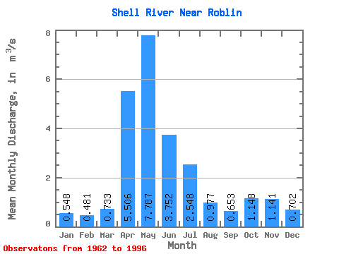
| Statistic | Jan | Feb | Mar | Apr | May | Jun | Jul | Aug | Sep | Oct | Nov | Dec | Annual |
|---|---|---|---|---|---|---|---|---|---|---|---|---|---|
| Mean | 0.55 | 0.48 | 0.73 | 5.51 | 7.79 | 3.75 | 2.55 | 0.98 | 0.65 | 1.15 | 1.14 | 0.70 | 2.21 |
| Standard Deviation | 0.24 | 0.21 | 0.33 | 3.48 | 7.31 | 3.65 | 1.90 | 0.55 | 0.38 | 0.71 | 0.86 | 0.32 | 1.13 |
| Min | 0.06 | 0.09 | 0.14 | 1.41 | 0.91 | 0.56 | 0.35 | 0.34 | 0.23 | 0.44 | 0.48 | 0.18 | 0.74 |
| Max | 0.87 | 0.78 | 1.56 | 13.50 | 27.70 | 18.60 | 7.21 | 2.36 | 1.26 | 2.18 | 3.72 | 1.26 | 3.99 |
| Coefficient of Variation | 0.43 | 0.43 | 0.46 | 0.63 | 0.94 | 0.97 | 0.75 | 0.56 | 0.58 | 0.62 | 0.75 | 0.45 | 0.51 |
 Return to R-Arctic Net Home Page