|
|
|||||||||||||||||
| Point ID: 2878 | Downloads | Plots | Site Data | Code: 05MD007 |
|
|
|||||||||||||||||
| Download | |
|---|---|
| Site Descriptor Information | Site Time Series Data |
| Link to all available data | |
| View: | Time Series | All |
| Units: | m3/s |
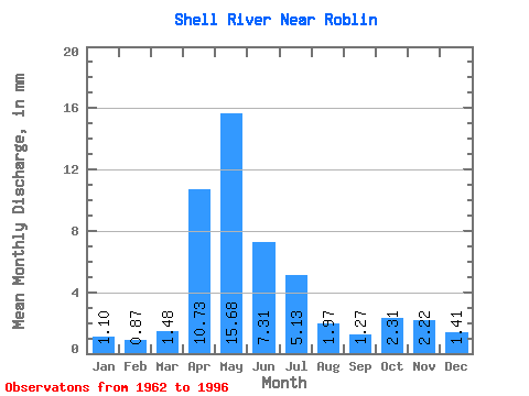
| Statistic | Jan | Feb | Mar | Apr | May | Jun | Jul | Aug | Sep | Oct | Nov | Dec | Annual |
|---|---|---|---|---|---|---|---|---|---|---|---|---|---|
| Mean | 1.10 | 0.88 | 1.48 | 10.73 | 15.68 | 7.31 | 5.13 | 1.97 | 1.27 | 2.31 | 2.22 | 1.41 | 52.35 |
| Standard Deviation | 0.48 | 0.38 | 0.67 | 6.79 | 14.72 | 7.12 | 3.83 | 1.11 | 0.74 | 1.42 | 1.67 | 0.64 | 26.83 |
| Min | 0.12 | 0.16 | 0.29 | 2.75 | 1.83 | 1.10 | 0.71 | 0.68 | 0.46 | 0.89 | 0.94 | 0.36 | 17.50 |
| Max | 1.76 | 1.42 | 3.14 | 26.31 | 55.77 | 36.25 | 14.52 | 4.75 | 2.46 | 4.39 | 7.25 | 2.54 | 94.69 |
| Coefficient of Variation | 0.43 | 0.43 | 0.46 | 0.63 | 0.94 | 0.97 | 0.75 | 0.56 | 0.58 | 0.62 | 0.75 | 0.45 | 0.51 |
 Return to R-Arctic Net Home Page