|
|
|||||||||||||||||
| Point ID: 2874 | Downloads | Plots | Site Data | Code: 05LN003 |
|
|
|||||||||||||||||
| Download | |
|---|---|
| Site Descriptor Information | Site Time Series Data |
| Link to all available data | |
| View: | Time Series | All |
| Units: | mm |
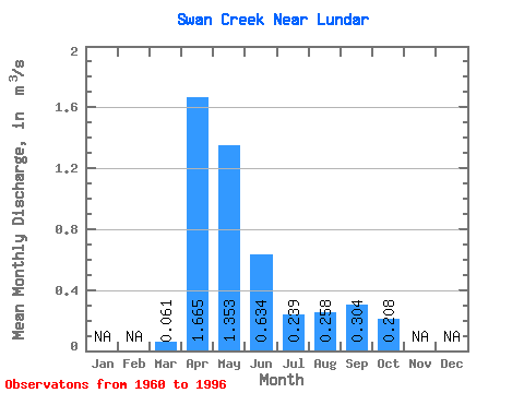
| Statistic | Jan | Feb | Mar | Apr | May | Jun | Jul | Aug | Sep | Oct | Nov | Dec | Annual |
|---|---|---|---|---|---|---|---|---|---|---|---|---|---|
| Mean | 0.06 | 1.67 | 1.35 | 0.63 | 0.24 | 0.26 | 0.30 | 0.21 | |||||
| Standard Deviation | 0.11 | 2.93 | 2.74 | 1.41 | 0.42 | 0.86 | 1.27 | 0.80 | |||||
| Min | 0.00 | 0.01 | 0.00 | 0.00 | 0.00 | 0.00 | 0.00 | 0.00 | |||||
| Max | 0.44 | 16.10 | 11.00 | 6.77 | 2.00 | 5.16 | 7.62 | 4.83 | |||||
| Coefficient of Variation | 1.77 | 1.76 | 2.02 | 2.22 | 1.77 | 3.33 | 4.17 | 3.86 |
 Return to R-Arctic Net Home Page