|
|
|||||||||||||||||
| Point ID: 2874 | Downloads | Plots | Site Data | Code: 05LN003 |
|
|
|||||||||||||||||
| Download | |
|---|---|
| Site Descriptor Information | Site Time Series Data |
| Link to all available data | |
| View: | Time Series | All |
| Units: | m3/s |
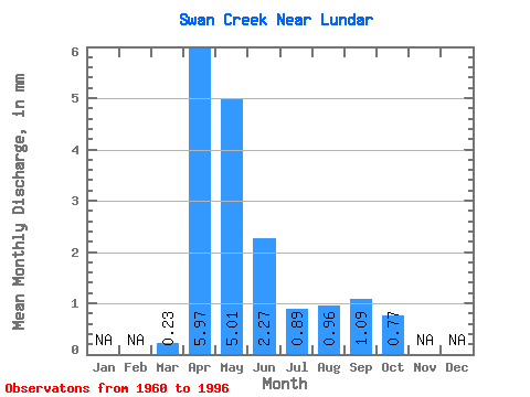
| Statistic | Jan | Feb | Mar | Apr | May | Jun | Jul | Aug | Sep | Oct | Nov | Dec | Annual |
|---|---|---|---|---|---|---|---|---|---|---|---|---|---|
| Mean | 0.23 | 5.97 | 5.01 | 2.27 | 0.89 | 0.95 | 1.09 | 0.77 | |||||
| Standard Deviation | 0.40 | 10.50 | 10.15 | 5.05 | 1.57 | 3.18 | 4.55 | 2.97 | |||||
| Min | 0.00 | 0.03 | 0.00 | 0.00 | 0.00 | 0.00 | 0.00 | 0.00 | |||||
| Max | 1.62 | 57.72 | 40.74 | 24.27 | 7.41 | 19.11 | 27.32 | 17.89 | |||||
| Coefficient of Variation | 1.77 | 1.76 | 2.02 | 2.22 | 1.77 | 3.33 | 4.17 | 3.86 |
 Return to R-Arctic Net Home Page