|
|
|||||||||||||||||
| Point ID: 2871 | Downloads | Plots | Site Data | Code: 05LM001 |
|
|
|||||||||||||||||
| Download | |
|---|---|
| Site Descriptor Information | Site Time Series Data |
| Link to all available data | |
| View: | Time Series | All |
| Units: | mm |
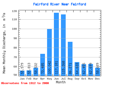
| Statistic | Jan | Feb | Mar | Apr | May | Jun | Jul | Aug | Sep | Oct | Nov | Dec | Annual |
|---|---|---|---|---|---|---|---|---|---|---|---|---|---|
| Mean | 55.58 | 55.81 | 58.53 | 73.48 | 100.04 | 117.18 | 115.27 | 86.27 | 64.63 | 62.45 | 62.70 | 58.69 | 74.64 |
| Standard Deviation | 49.02 | 46.35 | 45.23 | 59.04 | 90.91 | 96.89 | 84.99 | 71.52 | 60.47 | 59.67 | 54.02 | 52.54 | 52.19 |
| Min | 0.00 | 0.00 | 0.00 | 0.00 | 0.00 | 0.00 | 1.80 | 1.84 | 0.65 | 0.00 | 1.22 | 0.00 | 1.75 |
| Max | 192.00 | 190.00 | 181.00 | 204.00 | 318.00 | 330.00 | 301.00 | 240.00 | 228.00 | 220.00 | 209.00 | 200.00 | 200.92 |
| Coefficient of Variation | 0.88 | 0.83 | 0.77 | 0.80 | 0.91 | 0.83 | 0.74 | 0.83 | 0.94 | 0.95 | 0.86 | 0.90 | 0.70 |
 Return to R-Arctic Net Home Page