|
|
|||||||||||||||||
| Point ID: 2871 | Downloads | Plots | Site Data | Code: 05LM001 |
|
|
|||||||||||||||||
| Download | |
|---|---|
| Site Descriptor Information | Site Time Series Data |
| Link to all available data | |
| View: | Time Series | All |
| Units: | m3/s |
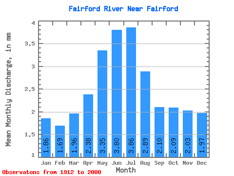
| Statistic | Jan | Feb | Mar | Apr | May | Jun | Jul | Aug | Sep | Oct | Nov | Dec | Annual |
|---|---|---|---|---|---|---|---|---|---|---|---|---|---|
| Mean | 1.86 | 1.70 | 1.96 | 2.38 | 3.35 | 3.80 | 3.86 | 2.89 | 2.10 | 2.09 | 2.03 | 1.97 | 29.48 |
| Standard Deviation | 1.64 | 1.42 | 1.52 | 1.92 | 3.05 | 3.14 | 2.85 | 2.40 | 1.96 | 2.00 | 1.75 | 1.76 | 20.61 |
| Min | 0.00 | 0.00 | 0.00 | 0.00 | 0.00 | 0.00 | 0.06 | 0.06 | 0.02 | 0.00 | 0.04 | 0.00 | 0.69 |
| Max | 6.43 | 5.80 | 6.07 | 6.62 | 10.66 | 10.71 | 10.09 | 8.04 | 7.40 | 7.37 | 6.78 | 6.70 | 79.36 |
| Coefficient of Variation | 0.88 | 0.83 | 0.77 | 0.80 | 0.91 | 0.83 | 0.74 | 0.83 | 0.94 | 0.95 | 0.86 | 0.90 | 0.70 |
 Return to R-Arctic Net Home Page