|
|
|||||||||||||||||
| Point ID: 287 | Downloads | Plots | Site Data | Code: 05BH009 |
|
|
|||||||||||||||||
| Download | |
|---|---|
| Site Descriptor Information | Site Time Series Data |
| Link to all available data | |
| View: | Time Series | All |
| Units: | mm |
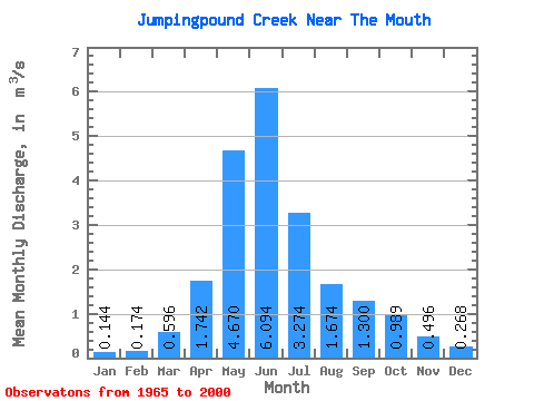
| Statistic | Jan | Feb | Mar | Apr | May | Jun | Jul | Aug | Sep | Oct | Nov | Dec | Annual |
|---|---|---|---|---|---|---|---|---|---|---|---|---|---|
| Mean | 0.14 | 0.17 | 0.60 | 1.74 | 4.67 | 6.09 | 3.27 | 1.67 | 1.30 | 0.99 | 0.50 | 0.27 | 1.67 |
| Standard Deviation | 0.11 | 0.12 | 0.60 | 0.92 | 3.31 | 4.30 | 3.57 | 1.65 | 1.33 | 1.02 | 0.30 | 0.17 | 0.84 |
| Min | 0.01 | 0.00 | 0.03 | 0.43 | 0.58 | 0.61 | 0.36 | 0.10 | 0.19 | 0.25 | 0.13 | 0.03 | 0.42 |
| Max | 0.38 | 0.52 | 2.11 | 3.94 | 12.20 | 15.40 | 16.20 | 7.40 | 5.56 | 4.76 | 1.58 | 0.69 | 3.49 |
| Coefficient of Variation | 0.74 | 0.71 | 1.00 | 0.53 | 0.71 | 0.71 | 1.09 | 0.99 | 1.02 | 1.03 | 0.60 | 0.65 | 0.51 |
 Return to R-Arctic Net Home Page