|
|
|||||||||||||||||
| Point ID: 287 | Downloads | Plots | Site Data | Code: 05BH009 |
|
|
|||||||||||||||||
| Download | |
|---|---|
| Site Descriptor Information | Site Time Series Data |
| Link to all available data | |
| View: | Time Series | All |
| Units: | m3/s |
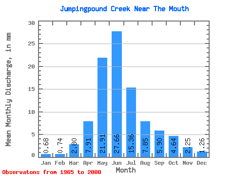
| Statistic | Jan | Feb | Mar | Apr | May | Jun | Jul | Aug | Sep | Oct | Nov | Dec | Annual |
|---|---|---|---|---|---|---|---|---|---|---|---|---|---|
| Mean | 0.68 | 0.74 | 2.80 | 7.91 | 21.90 | 27.66 | 15.36 | 7.85 | 5.90 | 4.64 | 2.25 | 1.26 | 92.06 |
| Standard Deviation | 0.50 | 0.53 | 2.80 | 4.19 | 15.51 | 19.52 | 16.74 | 7.75 | 6.04 | 4.78 | 1.34 | 0.81 | 46.56 |
| Min | 0.02 | 0.00 | 0.12 | 1.93 | 2.73 | 2.79 | 1.70 | 0.46 | 0.84 | 1.19 | 0.61 | 0.16 | 23.12 |
| Max | 1.77 | 2.20 | 9.90 | 17.89 | 57.22 | 69.91 | 75.98 | 34.71 | 25.24 | 22.32 | 7.17 | 3.25 | 192.78 |
| Coefficient of Variation | 0.74 | 0.71 | 1.00 | 0.53 | 0.71 | 0.71 | 1.09 | 0.99 | 1.02 | 1.03 | 0.60 | 0.65 | 0.51 |
 Return to R-Arctic Net Home Page