|
|
|||||||||||||||||
| Point ID: 2861 | Downloads | Plots | Site Data | Code: 05LL017 |
|
|
|||||||||||||||||
| Download | |
|---|---|
| Site Descriptor Information | Site Time Series Data |
| Link to all available data | |
| View: | Time Series | All |
| Units: | mm |
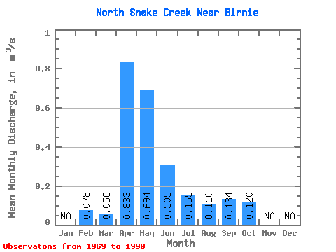
| Statistic | Jan | Feb | Mar | Apr | May | Jun | Jul | Aug | Sep | Oct | Nov | Dec | Annual |
|---|---|---|---|---|---|---|---|---|---|---|---|---|---|
| Mean | 0.08 | 0.06 | 0.83 | 0.69 | 0.30 | 0.15 | 0.11 | 0.13 | 0.12 | ||||
| Standard Deviation | 0.08 | 0.53 | 0.91 | 0.26 | 0.20 | 0.21 | 0.32 | 0.10 | |||||
| Min | 0.08 | 0.00 | 0.11 | 0.04 | 0.00 | 0.00 | 0.00 | 0.00 | 0.00 | ||||
| Max | 0.08 | 0.35 | 2.02 | 3.29 | 1.02 | 0.82 | 0.89 | 1.50 | 0.40 | ||||
| Coefficient of Variation | 1.40 | 0.64 | 1.30 | 0.86 | 1.32 | 1.89 | 2.39 | 0.86 |
 Return to R-Arctic Net Home Page