|
|
|||||||||||||||||
| Point ID: 2861 | Downloads | Plots | Site Data | Code: 05LL017 |
|
|
|||||||||||||||||
| Download | |
|---|---|
| Site Descriptor Information | Site Time Series Data |
| Link to all available data | |
| View: | Time Series | All |
| Units: | m3/s |
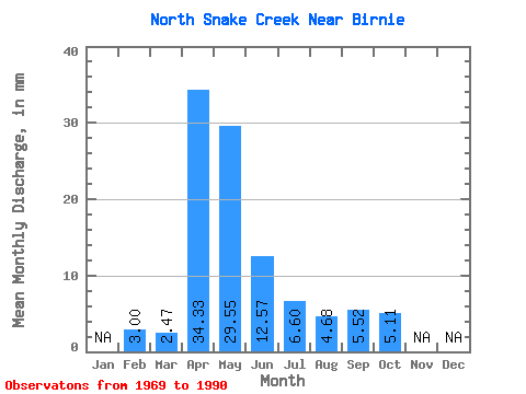
| Statistic | Jan | Feb | Mar | Apr | May | Jun | Jul | Aug | Sep | Oct | Nov | Dec | Annual |
|---|---|---|---|---|---|---|---|---|---|---|---|---|---|
| Mean | 3.03 | 2.48 | 34.33 | 29.56 | 12.55 | 6.61 | 4.67 | 5.51 | 5.09 | ||||
| Standard Deviation | 3.46 | 22.00 | 38.58 | 10.81 | 8.74 | 8.81 | 13.19 | 4.36 | |||||
| Min | 3.03 | 0.00 | 4.70 | 1.53 | 0.04 | 0.00 | 0.00 | 0.00 | 0.00 | ||||
| Max | 3.03 | 14.86 | 83.24 | 140.07 | 42.03 | 34.83 | 37.89 | 61.81 | 17.03 | ||||
| Coefficient of Variation | 1.40 | 0.64 | 1.30 | 0.86 | 1.32 | 1.89 | 2.39 | 0.86 |
 Return to R-Arctic Net Home Page