|
|
|||||||||||||||||
| Point ID: 2860 | Downloads | Plots | Site Data | Code: 05LL015 |
|
|
|||||||||||||||||
| Download | |
|---|---|
| Site Descriptor Information | Site Time Series Data |
| Link to all available data | |
| View: | Time Series | All |
| Units: | mm |
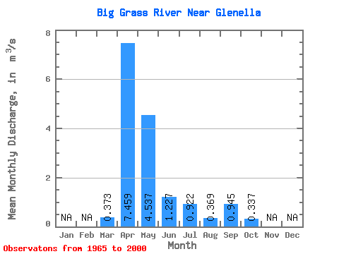
| Statistic | Jan | Feb | Mar | Apr | May | Jun | Jul | Aug | Sep | Oct | Nov | Dec | Annual |
|---|---|---|---|---|---|---|---|---|---|---|---|---|---|
| Mean | 0.37 | 7.46 | 4.54 | 1.23 | 0.92 | 0.37 | 0.94 | 0.34 | |||||
| Standard Deviation | 0.59 | 9.64 | 6.49 | 1.49 | 1.68 | 0.80 | 4.08 | 0.91 | |||||
| Min | 0.00 | 0.10 | 0.01 | 0.00 | 0.00 | 0.00 | 0.00 | 0.00 | |||||
| Max | 2.57 | 51.50 | 24.30 | 8.35 | 6.17 | 3.65 | 23.10 | 5.12 | |||||
| Coefficient of Variation | 1.59 | 1.29 | 1.43 | 1.21 | 1.82 | 2.17 | 4.32 | 2.71 |
 Return to R-Arctic Net Home Page