|
|
|||||||||||||||||
| Point ID: 2860 | Downloads | Plots | Site Data | Code: 05LL015 |
|
|
|||||||||||||||||
| Download | |
|---|---|
| Site Descriptor Information | Site Time Series Data |
| Link to all available data | |
| View: | Time Series | All |
| Units: | m3/s |
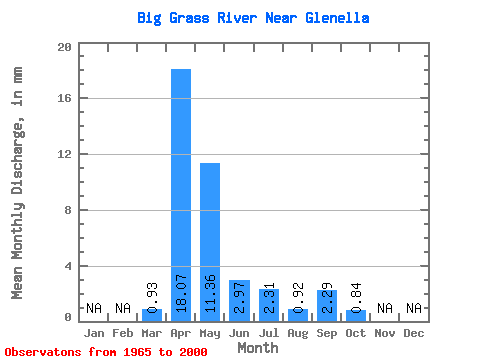
| Statistic | Jan | Feb | Mar | Apr | May | Jun | Jul | Aug | Sep | Oct | Nov | Dec | Annual |
|---|---|---|---|---|---|---|---|---|---|---|---|---|---|
| Mean | 0.93 | 18.07 | 11.36 | 2.97 | 2.31 | 0.92 | 2.29 | 0.84 | |||||
| Standard Deviation | 1.49 | 23.35 | 16.24 | 3.61 | 4.21 | 2.00 | 9.89 | 2.29 | |||||
| Min | 0.00 | 0.25 | 0.02 | 0.01 | 0.00 | 0.00 | 0.00 | 0.00 | |||||
| Max | 6.43 | 124.75 | 60.82 | 20.23 | 15.44 | 9.13 | 55.96 | 12.81 | |||||
| Coefficient of Variation | 1.59 | 1.29 | 1.43 | 1.21 | 1.82 | 2.17 | 4.32 | 2.71 |
 Return to R-Arctic Net Home Page