|
|
|||||||||||||||||
| Point ID: 286 | Downloads | Plots | Site Data | Code: 05BH008 |
|
|
|||||||||||||||||
| Download | |
|---|---|
| Site Descriptor Information | Site Time Series Data |
| Link to all available data | |
| View: | Time Series | All |
| Units: | mm |
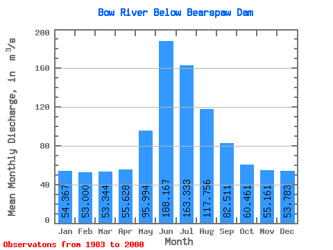
| Statistic | Jan | Feb | Mar | Apr | May | Jun | Jul | Aug | Sep | Oct | Nov | Dec | Annual |
|---|---|---|---|---|---|---|---|---|---|---|---|---|---|
| Mean | 54.37 | 53.00 | 53.34 | 55.63 | 95.99 | 188.17 | 163.33 | 117.76 | 82.51 | 60.46 | 55.16 | 53.78 | 86.12 |
| Standard Deviation | 6.29 | 5.06 | 5.25 | 7.16 | 23.40 | 70.49 | 46.43 | 28.05 | 15.88 | 10.88 | 8.90 | 9.87 | 13.52 |
| Min | 42.90 | 44.70 | 39.10 | 44.10 | 53.90 | 114.00 | 101.00 | 82.00 | 57.10 | 44.80 | 42.70 | 40.10 | 66.12 |
| Max | 66.00 | 64.60 | 61.40 | 70.10 | 136.00 | 336.00 | 266.00 | 180.00 | 115.00 | 75.10 | 68.40 | 73.90 | 110.77 |
| Coefficient of Variation | 0.12 | 0.10 | 0.10 | 0.13 | 0.24 | 0.38 | 0.28 | 0.24 | 0.19 | 0.18 | 0.16 | 0.18 | 0.16 |
 Return to R-Arctic Net Home Page