|
|
|||||||||||||||||
| Point ID: 286 | Downloads | Plots | Site Data | Code: 05BH008 |
|
|
|||||||||||||||||
| Download | |
|---|---|
| Site Descriptor Information | Site Time Series Data |
| Link to all available data | |
| View: | Time Series | All |
| Units: | m3/s |
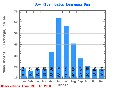
| Statistic | Jan | Feb | Mar | Apr | May | Jun | Jul | Aug | Sep | Oct | Nov | Dec | Annual |
|---|---|---|---|---|---|---|---|---|---|---|---|---|---|
| Mean | 18.74 | 16.64 | 18.39 | 18.56 | 33.09 | 62.77 | 56.29 | 40.59 | 27.52 | 20.84 | 18.40 | 18.54 | 349.82 |
| Standard Deviation | 2.17 | 1.59 | 1.81 | 2.39 | 8.06 | 23.52 | 16.00 | 9.67 | 5.30 | 3.75 | 2.97 | 3.40 | 54.91 |
| Min | 14.79 | 14.04 | 13.48 | 14.71 | 18.58 | 38.03 | 34.81 | 28.26 | 19.05 | 15.44 | 14.24 | 13.82 | 268.55 |
| Max | 22.75 | 20.29 | 21.16 | 23.39 | 46.87 | 112.09 | 91.68 | 62.04 | 38.36 | 25.88 | 22.82 | 25.47 | 449.91 |
| Coefficient of Variation | 0.12 | 0.10 | 0.10 | 0.13 | 0.24 | 0.38 | 0.28 | 0.24 | 0.19 | 0.18 | 0.16 | 0.18 | 0.16 |
 Return to R-Arctic Net Home Page