|
|
|||||||||||||||||
| Point ID: 2856 | Downloads | Plots | Site Data | Code: 05LL009 |
|
|
|||||||||||||||||
| Download | |
|---|---|
| Site Descriptor Information | Site Time Series Data |
| Link to all available data | |
| View: | Time Series | All |
| Units: | mm |
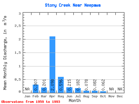
| Statistic | Jan | Feb | Mar | Apr | May | Jun | Jul | Aug | Sep | Oct | Nov | Dec | Annual |
|---|---|---|---|---|---|---|---|---|---|---|---|---|---|
| Mean | 0.31 | 0.20 | 2.10 | 0.60 | 0.21 | 0.18 | 0.08 | 0.08 | 0.06 | ||||
| Standard Deviation | 0.34 | 1.77 | 0.93 | 0.45 | 0.35 | 0.19 | 0.22 | 0.05 | |||||
| Min | 0.31 | 0.00 | 0.12 | 0.05 | 0.01 | 0.00 | 0.00 | 0.00 | 0.00 | ||||
| Max | 0.31 | 1.38 | 5.31 | 4.30 | 2.62 | 1.70 | 1.06 | 1.19 | 0.23 | ||||
| Coefficient of Variation | 1.71 | 0.84 | 1.56 | 2.10 | 1.94 | 2.43 | 2.65 | 0.86 |
 Return to R-Arctic Net Home Page