|
|
|||||||||||||||||
| Point ID: 2856 | Downloads | Plots | Site Data | Code: 05LL009 |
|
|
|||||||||||||||||
| Download | |
|---|---|
| Site Descriptor Information | Site Time Series Data |
| Link to all available data | |
| View: | Time Series | All |
| Units: | m3/s |
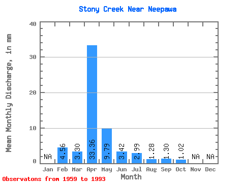
| Statistic | Jan | Feb | Mar | Apr | May | Jun | Jul | Aug | Sep | Oct | Nov | Dec | Annual |
|---|---|---|---|---|---|---|---|---|---|---|---|---|---|
| Mean | 4.60 | 3.31 | 33.36 | 9.80 | 3.42 | 2.99 | 1.27 | 1.31 | 1.02 | ||||
| Standard Deviation | 5.67 | 28.11 | 15.23 | 7.18 | 5.80 | 3.10 | 3.47 | 0.87 | |||||
| Min | 4.60 | 0.00 | 1.91 | 0.84 | 0.14 | 0.00 | 0.00 | 0.00 | 0.00 | ||||
| Max | 4.60 | 22.67 | 84.44 | 70.65 | 41.66 | 27.93 | 17.41 | 18.92 | 3.76 | ||||
| Coefficient of Variation | 1.71 | 0.84 | 1.56 | 2.10 | 1.94 | 2.43 | 2.65 | 0.86 |
 Return to R-Arctic Net Home Page