|
|
|||||||||||||||||
| Point ID: 2853 | Downloads | Plots | Site Data | Code: 05LL006 |
|
|
|||||||||||||||||
| Download | |
|---|---|
| Site Descriptor Information | Site Time Series Data |
| Link to all available data | |
| View: | Time Series | All |
| Units: | mm |
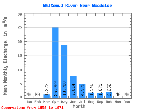
| Statistic | Jan | Feb | Mar | Apr | May | Jun | Jul | Aug | Sep | Oct | Nov | Dec | Annual |
|---|---|---|---|---|---|---|---|---|---|---|---|---|---|
| Mean | 1.37 | 25.09 | 18.70 | 7.81 | 4.97 | 1.95 | 1.87 | 2.25 | |||||
| Standard Deviation | 1.97 | 20.59 | 29.08 | 6.73 | 5.91 | 1.77 | 1.45 | 1.62 | |||||
| Min | 0.14 | 5.22 | 3.62 | 1.61 | 0.42 | 0.07 | 0.09 | 0.52 | |||||
| Max | 7.32 | 71.90 | 116.00 | 24.20 | 17.30 | 6.19 | 4.54 | 6.31 | |||||
| Coefficient of Variation | 1.44 | 0.82 | 1.56 | 0.86 | 1.19 | 0.91 | 0.78 | 0.72 |
 Return to R-Arctic Net Home Page