|
|
|||||||||||||||||
| Point ID: 2853 | Downloads | Plots | Site Data | Code: 05LL006 |
|
|
|||||||||||||||||
| Download | |
|---|---|
| Site Descriptor Information | Site Time Series Data |
| Link to all available data | |
| View: | Time Series | All |
| Units: | m3/s |
| Statistic | Jan | Feb | Mar | Apr | May | Jun | Jul | Aug | Sep | Oct | Nov | Dec | Annual |
|---|---|---|---|---|---|---|---|---|---|---|---|---|---|
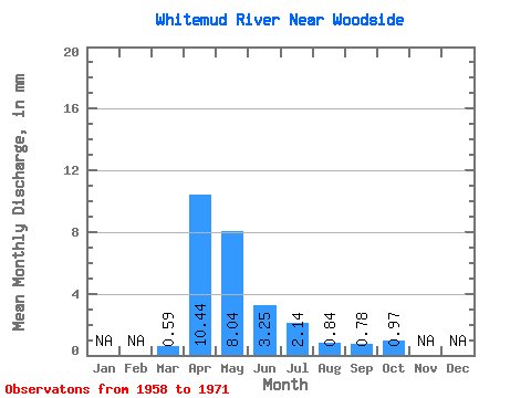
| Mean | 0.59 | 10.44 | 8.04 | 3.25 | 2.14 | 0.84 | 0.78 | 0.97 | |||||
| Standard Deviation | 0.85 | 8.56 | 12.50 | 2.80 | 2.54 | 0.76 | 0.60 | 0.70 | |||||
| Min | 0.06 | 2.17 | 1.56 | 0.67 | 0.18 | 0.03 | 0.04 | 0.22 | |||||
| Max | 3.15 | 29.91 | 49.86 | 10.07 | 7.44 | 2.66 | 1.89 | 2.71 | |||||
| Coefficient of Variation | 1.44 | 0.82 | 1.56 | 0.86 | 1.19 | 0.91 | 0.78 | 0.72 |
 Return to R-Arctic Net Home Page