|
|
|||||||||||||||||
| Point ID: 2849 | Downloads | Plots | Site Data | Code: 05LL001 |
|
|
|||||||||||||||||
| Download | |
|---|---|
| Site Descriptor Information | Site Time Series Data |
| Link to all available data | |
| View: | Time Series | All |
| Units: | mm |
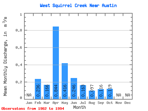
| Statistic | Jan | Feb | Mar | Apr | May | Jun | Jul | Aug | Sep | Oct | Nov | Dec | Annual |
|---|---|---|---|---|---|---|---|---|---|---|---|---|---|
| Mean | 0.24 | 0.17 | 0.84 | 0.42 | 0.25 | 0.16 | 0.10 | 0.12 | 0.12 | ||||
| Standard Deviation | 0.20 | 0.53 | 0.28 | 0.17 | 0.15 | 0.07 | 0.12 | 0.09 | |||||
| Min | 0.24 | 0.00 | 0.16 | 0.08 | 0.01 | 0.01 | 0.02 | 0.00 | 0.00 | ||||
| Max | 0.24 | 0.83 | 2.08 | 1.13 | 0.83 | 0.59 | 0.23 | 0.51 | 0.42 | ||||
| Coefficient of Variation | 1.21 | 0.63 | 0.67 | 0.71 | 0.91 | 0.77 | 1.07 | 0.71 |
 Return to R-Arctic Net Home Page