|
|
|||||||||||||||||
| Point ID: 2849 | Downloads | Plots | Site Data | Code: 05LL001 |
|
|
|||||||||||||||||
| Download | |
|---|---|
| Site Descriptor Information | Site Time Series Data |
| Link to all available data | |
| View: | Time Series | All |
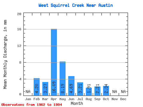
| Units: | m3/s |
| Statistic | Jan | Feb | Mar | Apr | May | Jun | Jul | Aug | Sep | Oct | Nov | Dec | Annual |
|---|---|---|---|---|---|---|---|---|---|---|---|---|---|
| Mean | 4.23 | 3.27 | 16.08 | 8.19 | 4.68 | 3.22 | 1.92 | 2.20 | 2.35 | ||||
| Standard Deviation | 3.95 | 10.17 | 5.49 | 3.33 | 2.93 | 1.47 | 2.35 | 1.68 | |||||
| Min | 4.23 | 0.00 | 2.99 | 1.59 | 0.19 | 0.10 | 0.32 | 0.00 | 0.00 | ||||
| Max | 4.23 | 16.29 | 39.64 | 22.25 | 15.89 | 11.64 | 4.63 | 9.78 | 8.37 | ||||
| Coefficient of Variation | 1.21 | 0.63 | 0.67 | 0.71 | 0.91 | 0.77 | 1.07 | 0.71 |
 Return to R-Arctic Net Home Page