|
|
|||||||||||||||||
| Point ID: 2847 | Downloads | Plots | Site Data | Code: 05LJ801 |
|
|
|||||||||||||||||
| Download | |
|---|---|
| Site Descriptor Information | Site Time Series Data |
| Link to all available data | |
| View: | Time Series | All |
| Units: | mm |
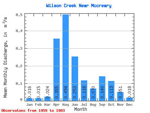
| Statistic | Jan | Feb | Mar | Apr | May | Jun | Jul | Aug | Sep | Oct | Nov | Dec | Annual |
|---|---|---|---|---|---|---|---|---|---|---|---|---|---|
| Mean | 0.02 | 0.01 | 0.02 | 0.35 | 0.49 | 0.25 | 0.12 | 0.07 | 0.14 | 0.11 | 0.05 | 0.02 | 0.16 |
| Standard Deviation | 0.02 | 0.01 | 0.02 | 0.23 | 0.42 | 0.26 | 0.14 | 0.10 | 0.32 | 0.14 | 0.04 | 0.01 | 0.07 |
| Min | 0.00 | 0.00 | 0.00 | 0.04 | 0.05 | 0.01 | 0.00 | 0.00 | 0.00 | 0.01 | 0.01 | 0.00 | 0.08 |
| Max | 0.05 | 0.05 | 0.06 | 0.87 | 1.88 | 1.04 | 0.48 | 0.43 | 1.56 | 0.53 | 0.11 | 0.05 | 0.31 |
| Coefficient of Variation | 0.95 | 1.02 | 0.73 | 0.64 | 0.85 | 1.01 | 1.23 | 1.43 | 2.29 | 1.27 | 0.73 | 0.63 | 0.46 |
 Return to R-Arctic Net Home Page