|
|
|||||||||||||||||
| Point ID: 2847 | Downloads | Plots | Site Data | Code: 05LJ801 |
|
|
|||||||||||||||||
| Download | |
|---|---|
| Site Descriptor Information | Site Time Series Data |
| Link to all available data | |
| View: | Time Series | All |
| Units: | m3/s |
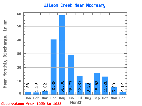
| Statistic | Jan | Feb | Mar | Apr | May | Jun | Jul | Aug | Sep | Oct | Nov | Dec | Annual |
|---|---|---|---|---|---|---|---|---|---|---|---|---|---|
| Mean | 1.93 | 1.58 | 2.80 | 40.35 | 58.09 | 28.76 | 13.83 | 8.26 | 15.89 | 13.22 | 5.83 | 2.15 | 220.13 |
| Standard Deviation | 1.83 | 1.62 | 2.04 | 25.67 | 49.44 | 29.08 | 17.07 | 11.78 | 36.41 | 16.85 | 4.29 | 1.35 | 100.26 |
| Min | 0.35 | 0.32 | 0.47 | 4.32 | 5.76 | 1.25 | 0.23 | 0.00 | 0.23 | 0.94 | 0.68 | 0.47 | 112.52 |
| Max | 5.99 | 5.57 | 6.70 | 98.49 | 220.91 | 118.28 | 56.40 | 50.18 | 177.43 | 61.93 | 12.85 | 5.52 | 429.52 |
| Coefficient of Variation | 0.95 | 1.02 | 0.73 | 0.64 | 0.85 | 1.01 | 1.23 | 1.43 | 2.29 | 1.27 | 0.73 | 0.63 | 0.46 |
 Return to R-Arctic Net Home Page