|
|
|||||||||||||||||
| Point ID: 2845 | Downloads | Plots | Site Data | Code: 05LJ047 |
|
|
|||||||||||||||||
| Download | |
|---|---|
| Site Descriptor Information | Site Time Series Data |
| Link to all available data | |
| View: | Time Series | All |
| Units: | mm |
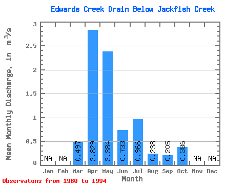
| Statistic | Jan | Feb | Mar | Apr | May | Jun | Jul | Aug | Sep | Oct | Nov | Dec | Annual |
|---|---|---|---|---|---|---|---|---|---|---|---|---|---|
| Mean | 0.50 | 2.83 | 2.38 | 0.73 | 0.97 | 0.24 | 0.20 | 0.39 | |||||
| Standard Deviation | 0.72 | 1.88 | 2.44 | 0.57 | 1.87 | 0.39 | 0.33 | 0.67 | |||||
| Min | 0.00 | 0.54 | 0.10 | 0.04 | 0.01 | 0.00 | 0.01 | 0.01 | |||||
| Max | 2.50 | 5.87 | 9.11 | 1.82 | 6.42 | 1.50 | 1.21 | 2.56 | |||||
| Coefficient of Variation | 1.44 | 0.66 | 1.02 | 0.77 | 1.93 | 1.65 | 1.59 | 1.73 |
 Return to R-Arctic Net Home Page