|
|
|||||||||||||||||
| Point ID: 2845 | Downloads | Plots | Site Data | Code: 05LJ047 |
|
|
|||||||||||||||||
| Download | |
|---|---|
| Site Descriptor Information | Site Time Series Data |
| Link to all available data | |
| View: | Time Series | All |
| Units: | m3/s |
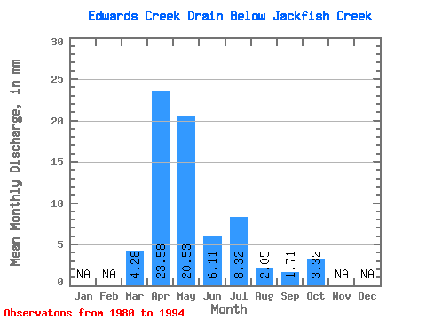
| Statistic | Jan | Feb | Mar | Apr | May | Jun | Jul | Aug | Sep | Oct | Nov | Dec | Annual |
|---|---|---|---|---|---|---|---|---|---|---|---|---|---|
| Mean | 4.28 | 23.58 | 20.53 | 6.11 | 8.32 | 2.05 | 1.71 | 3.32 | |||||
| Standard Deviation | 6.17 | 15.65 | 21.02 | 4.73 | 16.09 | 3.37 | 2.71 | 5.76 | |||||
| Min | 0.00 | 4.52 | 0.85 | 0.30 | 0.10 | 0.00 | 0.06 | 0.10 | |||||
| Max | 21.53 | 48.92 | 78.45 | 15.17 | 55.28 | 12.92 | 10.09 | 22.04 | |||||
| Coefficient of Variation | 1.44 | 0.66 | 1.02 | 0.77 | 1.93 | 1.65 | 1.59 | 1.73 |
 Return to R-Arctic Net Home Page