|
|
|||||||||||||||||
| Point ID: 2842 | Downloads | Plots | Site Data | Code: 05LJ035 |
|
|
|||||||||||||||||
| Download | |
|---|---|
| Site Descriptor Information | Site Time Series Data |
| Link to all available data | |
| View: | Time Series | All |
| Units: | mm |
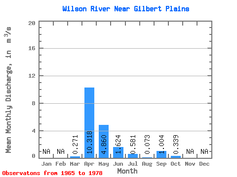
| Statistic | Jan | Feb | Mar | Apr | May | Jun | Jul | Aug | Sep | Oct | Nov | Dec | Annual |
|---|---|---|---|---|---|---|---|---|---|---|---|---|---|
| Mean | 0.27 | 10.32 | 4.86 | 1.62 | 0.58 | 0.07 | 1.00 | 0.34 | |||||
| Standard Deviation | 0.54 | 6.56 | 6.94 | 2.20 | 0.88 | 0.09 | 2.55 | 0.48 | |||||
| Min | 0.00 | 0.26 | 0.11 | 0.02 | 0.00 | 0.00 | 0.00 | 0.00 | |||||
| Max | 1.60 | 20.60 | 22.30 | 7.42 | 3.03 | 0.29 | 9.47 | 1.36 | |||||
| Coefficient of Variation | 2.01 | 0.64 | 1.43 | 1.35 | 1.51 | 1.20 | 2.54 | 1.41 |
 Return to R-Arctic Net Home Page