|
|
|||||||||||||||||
| Point ID: 2842 | Downloads | Plots | Site Data | Code: 05LJ035 |
|
|
|||||||||||||||||
| Download | |
|---|---|
| Site Descriptor Information | Site Time Series Data |
| Link to all available data | |
| View: | Time Series | All |
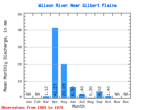
| Units: | m3/s |
| Statistic | Jan | Feb | Mar | Apr | May | Jun | Jul | Aug | Sep | Oct | Nov | Dec | Annual |
|---|---|---|---|---|---|---|---|---|---|---|---|---|---|
| Mean | 1.12 | 41.27 | 20.08 | 6.50 | 2.40 | 0.30 | 4.02 | 1.40 | |||||
| Standard Deviation | 2.25 | 26.25 | 28.67 | 8.80 | 3.63 | 0.36 | 10.21 | 1.98 | |||||
| Min | 0.00 | 1.04 | 0.45 | 0.06 | 0.00 | 0.00 | 0.00 | 0.00 | |||||
| Max | 6.61 | 82.40 | 92.16 | 29.68 | 12.52 | 1.21 | 37.88 | 5.62 | |||||
| Coefficient of Variation | 2.01 | 0.64 | 1.43 | 1.35 | 1.51 | 1.20 | 2.54 | 1.41 |
 Return to R-Arctic Net Home Page