|
|
|||||||||||||||||
| Point ID: 2840 | Downloads | Plots | Site Data | Code: 05LJ032 |
|
|
|||||||||||||||||
| Download | |
|---|---|
| Site Descriptor Information | Site Time Series Data |
| Link to all available data | |
| View: | Time Series | All |
| Units: | mm |
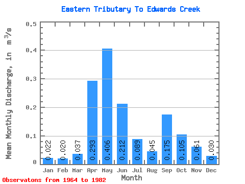
| Statistic | Jan | Feb | Mar | Apr | May | Jun | Jul | Aug | Sep | Oct | Nov | Dec | Annual |
|---|---|---|---|---|---|---|---|---|---|---|---|---|---|
| Mean | 0.02 | 0.02 | 0.04 | 0.29 | 0.41 | 0.21 | 0.09 | 0.04 | 0.17 | 0.10 | 0.06 | 0.03 | 0.13 |
| Standard Deviation | 0.01 | 0.01 | 0.06 | 0.24 | 0.35 | 0.18 | 0.09 | 0.03 | 0.34 | 0.10 | 0.05 | 0.01 | 0.05 |
| Min | 0.00 | 0.00 | 0.00 | 0.05 | 0.03 | 0.02 | 0.02 | 0.01 | 0.01 | 0.02 | 0.02 | 0.01 | 0.05 |
| Max | 0.05 | 0.04 | 0.27 | 0.78 | 1.34 | 0.68 | 0.39 | 0.10 | 1.44 | 0.34 | 0.21 | 0.07 | 0.23 |
| Coefficient of Variation | 0.56 | 0.55 | 1.56 | 0.81 | 0.86 | 0.86 | 1.06 | 0.59 | 1.92 | 0.95 | 0.82 | 0.51 | 0.36 |
 Return to R-Arctic Net Home Page