|
|
|||||||||||||||||
| Point ID: 2840 | Downloads | Plots | Site Data | Code: 05LJ032 |
|
|
|||||||||||||||||
| Download | |
|---|---|
| Site Descriptor Information | Site Time Series Data |
| Link to all available data | |
| View: | Time Series | All |
| Units: | m3/s |
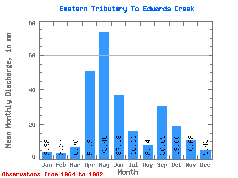
| Statistic | Jan | Feb | Mar | Apr | May | Jun | Jul | Aug | Sep | Oct | Nov | Dec | Annual |
|---|---|---|---|---|---|---|---|---|---|---|---|---|---|
| Mean | 4.04 | 3.35 | 6.75 | 51.28 | 73.50 | 37.10 | 16.03 | 8.22 | 30.71 | 18.91 | 10.75 | 5.46 | 273.29 |
| Standard Deviation | 2.25 | 1.84 | 10.55 | 41.55 | 63.33 | 31.86 | 16.93 | 4.88 | 58.95 | 17.99 | 8.79 | 2.80 | 97.75 |
| Min | 0.00 | 0.00 | 0.54 | 8.93 | 4.89 | 3.33 | 4.34 | 2.71 | 2.63 | 3.98 | 3.33 | 1.09 | 98.62 |
| Max | 9.23 | 6.92 | 48.31 | 136.96 | 242.47 | 119.79 | 70.93 | 18.46 | 252.19 | 60.98 | 36.95 | 11.94 | 499.88 |
| Coefficient of Variation | 0.56 | 0.55 | 1.56 | 0.81 | 0.86 | 0.86 | 1.06 | 0.59 | 1.92 | 0.95 | 0.82 | 0.51 | 0.36 |
 Return to R-Arctic Net Home Page