|
|
|||||||||||||||||
| Point ID: 2831 | Downloads | Plots | Site Data | Code: 05LJ021 |
|
|
|||||||||||||||||
| Download | |
|---|---|
| Site Descriptor Information | Site Time Series Data |
| Link to all available data | |
| View: | Time Series | All |
| Units: | mm |
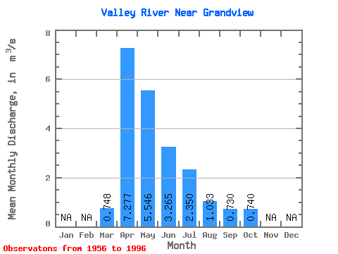
| Statistic | Jan | Feb | Mar | Apr | May | Jun | Jul | Aug | Sep | Oct | Nov | Dec | Annual |
|---|---|---|---|---|---|---|---|---|---|---|---|---|---|
| Mean | 0.75 | 7.28 | 5.55 | 3.27 | 2.35 | 1.03 | 0.73 | 0.74 | |||||
| Standard Deviation | 0.75 | 5.40 | 7.74 | 3.67 | 2.97 | 1.46 | 0.98 | 0.75 | |||||
| Min | 0.06 | 0.60 | 0.13 | 0.05 | 0.00 | 0.01 | 0.00 | 0.00 | |||||
| Max | 3.82 | 22.20 | 37.70 | 15.50 | 14.20 | 8.05 | 3.56 | 3.13 | |||||
| Coefficient of Variation | 1.01 | 0.74 | 1.40 | 1.12 | 1.26 | 1.42 | 1.35 | 1.01 |
 Return to R-Arctic Net Home Page