|
|
|||||||||||||||||
| Point ID: 2831 | Downloads | Plots | Site Data | Code: 05LJ021 |
|
|
|||||||||||||||||
| Download | |
|---|---|
| Site Descriptor Information | Site Time Series Data |
| Link to all available data | |
| View: | Time Series | All |
| Units: | m3/s |
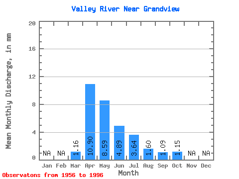
| Statistic | Jan | Feb | Mar | Apr | May | Jun | Jul | Aug | Sep | Oct | Nov | Dec | Annual |
|---|---|---|---|---|---|---|---|---|---|---|---|---|---|
| Mean | 1.16 | 10.90 | 8.59 | 4.89 | 3.64 | 1.60 | 1.09 | 1.15 | |||||
| Standard Deviation | 1.17 | 8.08 | 11.98 | 5.50 | 4.59 | 2.26 | 1.48 | 1.16 | |||||
| Min | 0.09 | 0.89 | 0.20 | 0.07 | 0.00 | 0.02 | 0.00 | 0.00 | |||||
| Max | 5.91 | 33.26 | 58.36 | 23.22 | 21.98 | 12.46 | 5.33 | 4.84 | |||||
| Coefficient of Variation | 1.01 | 0.74 | 1.40 | 1.12 | 1.26 | 1.42 | 1.35 | 1.01 |
 Return to R-Arctic Net Home Page